Goal
This effort strengthens land rights of nearly 100,000 acres of traditional territory of the Siekopai indigenous group. This is achieved by improving access to traditional lands and by re-establishing forest “Chakras” which are a form of traditional sustainable agroforestry use. In addition to providing the Siekopai with food sovereignty and income potential, this traditional low impact land use protects the forest which is home to millions of plant and animal species and helps mitigate the effects of climate change on the forests, which are exaggerated when the forest is disturbed or cleared.

Field Partner
YAKUM works to protect indigenous forest and build cultural, medicinal and food sovereignty, through reforestation with carefully selected native tree species and territory mapping. In the Shuar language, YAKUM means “Howler Monkey”, the species with the loudest call in the animal kingdom – the call to action. At this critical time in the history of the climate, YAKUM sets out to highlight the urgency of acting on deforestation to evade climate change, and change the way conservation works. They recognize that Indigenous people in many cases do conservation better than national park systems as part of their way of life, buffering the climate and protecting the forests.
Location
Amazonian Lowlands of Eastern Ecuador, Napo Prov.

Maps data © 2024 Google
The Importance of Protecting Siekopai Lands
The territories of the Siekopai include a very large portion of upper Amazonian headwaters in eastern Ecuador. These areas encompass a variety of habitat types including seasonally flooded Varzea Forest and lowland terra firme forest where there is no flooding. This area has some of the highest densities of animal and plant species. Helping to protect a large 100,000 acre area of the Siekopai territories ensures that these forests will not be converted to oil palm plantations or other uses which destroy the forest.


Family food forests and reforestation
Since 2018 YAKUM and committed families have planted 7 family and school food forests, with seeds from useful tree species across Ecuador. In 2020 new families are joining the effort and the Payaguaje family are building a Food Processing Lab in order to can, jar and dehydrate fruit production as well as extract fruit and nut oils.

Territorial mapping and cultural exchanges
Several Siekopai participated in a 4-month mapping project to identify deforestation and contamination threats to their territory, and important resources available in the forest that present potential opportunities to them. Since this project, in collaboration with YAKUM, the map team are mapping water sources free from oil and mining contamination, and are patrolling territory limits to identify and stop invaders from logging and poaching. Mapping is essential for establishing legal territorial rights with the Government of Ecuador and to resist incursions from threats by external parties.

Siekopai's Fight to Reclaim and Preserve Territory
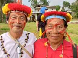
The Siekopai, or “people of many colors”, speak the language of Paicoca, part of the Tucanoan language group. They inhabit warmer lowland forests of Ecuador nearer the Peruvian border, overlapping the Cuyabeno Flora and Fauna Reserve. Their territory has been fragmented and they were displaced from their ancestral home, which they are fighting to reclaim. Affected by the Texaco-Chevron oil disaster, they live downstream from gold mining activity, and agrochemical runoff from vast palm oil plantations. The rivers they depend on for fish are no longer sustainable sources of food and drinking water. The Siekopai are highly knowledgeable about their forests and have effectively kept tens of thousands of hectares of forest intact against all odds. YAKUM has supported the planting of Siekopai food forests and territory mapping work since 2018.

